Before using GLODAPv2.2020 data products, please read the
Fair Data Use Statement
Interactive Data Viewer
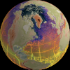 |
You can view GLODAP data using the interactive Digital Earth Viewer. You can watch an introductory video to the viewer here. |
Synthesis Files (GLODAPv2.2020)
The merged and adjusted GLODAPv2.2020 data product, prepared as described in Olsen et al. (2020) (submitted) can be accessed in a variety of formats:
.csv and .mat filesGlobal and regional synthesis files are available as csv and mat files via the GLODAP page at NOAA’s OCADS (former CDIAC) National Centers for Environmental Information (NCEI) data archive. For the csv files, the file EXPOCODE.txt can be used for translating cruise number, as given in the data files, to cruise expocodes. For the mat files the expocodes are supplied in a cell array. Please refer to Olsen et al. (2020), Olsen et al. (2019), Olsen et al. (2016), and Key et al. (2015) for further details on the content of these files.
|
||||||||||||||||||||||||||||||||||||||||||||||||||||
Ocean Data View formatThe global synthesis file is available in Ocean Data View (ODV) format from the ODV website. |
||||||||||||||||||||||||||||||||||||||||||||||||||||